This page provides information on current bridge, roadway and intersection improvement projects. You can find project details as presented at public information meetings which are typically held at the 30%, 60% and 90% design stage. For further information on these projects or other roadways that are not listed here, you may email TECM@collier.gov.
(Project Manager: Dennis McCoy, P.E.)
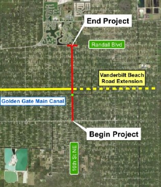 The project is located along 16th Street NE between Golden Gate Boulevard and Randall Boulevard:
- Two 11-foot travel lanes with 6-foot shoulders (4-foot paved plus 2-foot unpaved) along the entire length of the project
- 6-foot concrete sidewalk on the west side of the roadway
- New bridge over Golden Gate Main Canal with two 12-foot travel lanes (one in each direction), a 6-foot shoulder on the west side and 12-foot shoulder on the east side.
- New traffic signal at intersection of 16th Street NE and Randall Boulevard.
A public information meeting on the project's 60 percent design plans was held on Thursday, June 15, 2023. A handout had been created with all relevant information as well as conceptual maps (2 pages) and a typical section display.
(Project Manager: Ragaey Girgis, P.E.)
 The 10th Avenue SE project limits encompass approximately a 1.8-mile section of 10th Avenue SE from Everglades Boulevard N. to Desoto Boulevard N. The existing nine-foot travel lanes and narrow unpaved shoulders along this segment of 10th Avenue SE will be widened to 11-foot travel lanes and two-foot paved shoulders with roadside ditches on both sides. A six-foot concrete sidewalk will be constructed adjacent to the shoulder on the south side of 10th Avenue SE. A new bridge will be constructed over the Faka Union Canal. The proposed bridge will consist of two 12-foot travel lanes, six-foot shoulders, and a six-foot sidewalk. A new westbound to northbound right turn lane will be designed at Everglades Boulevard. On March 31st, 2026, the public was invited to review the 30% design concept(PDF, 4MB) and handouts were prepared in English(PDF, 4MB) and Spanish(PDF, 4MB) .
(Project Manager: Ragaey Girgis, P.E.)
 The project covers approximately 1.37 miles of 13th Street NW, from Golden Gate Boulevard to Vanderbilt Beach Road (VBR). The existing nine-foot travel lanes and narrow unpaved shoulders along this segment of 13th Street NW will be widened to 11-foot travel lanes, two-foot paved shoulders with roadside ditches on both sides and a six-foot sidewalk along the corridor. The existing bridge will be replaced, and 13th Street NW will be extended to connect with the VBR Extension, which is currently under construction. Improvements include a new signalized intersection at 13th Street NW and the VBR Extension, as well as roadway widening to add a dedicated right‑turn lane at Golden Gate Boulevard. On March 31st, 2026, the public was invited to review the 30% design concept(PDF, 5MB) and handouts were prepared in English(PDF, 2MB) and Spanish(PDF, 2MB) .
(Project Manager: Ragaey Girgis, P.E.)
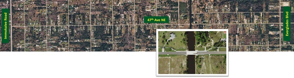
The project encompasses approximately a 3.06-mile section of 47th Avenue NE from the intersection with Immokalee Road extending east to Everglades Boulevard. The existing nine-foot westbound lane will be widened to 11-feet with an added two-foot paved shoulder. The existing nine-foot eastbound lane will be widened to 11-feet with an added one-foot paved shoulder and curb. A six-foot concrete sidewalk is proposed adjacent to the curb on the south side of the roadway. A new bridge will be constructed over the Golden Gate Main Canal. A traffic signal warrant analysis resulted in including a new traffic signal at the intersection with Immokalee Road. The intersection with Everglades Boulevard will see turn lane improvements. On March 18, 2026, the public was invited to review the 30% design concept(PDF, 10MB) and handouts were prepared in English(PDF, 634KB) and Spanish(PDF, 687KB) .
(Project Manager: Ragaey Girgis, P.E.)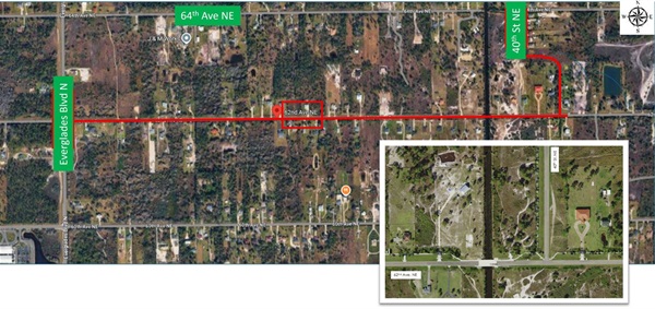
The project covers approximately 2.17 miles of 62nd Avenue NE, from Everglades Boulevard North to DeSoto Boulevard North. The project includes constructing a new bridge over the Faka Union Canal, resurfacing and widening the roadway to 11-foot lanes, and adding sidewalks along the south side of the corridor. This project will also extend 40th Street NE from its existing terminus, south of 64th Avenue NE to 62nd Avenue NE. A sidewalk will also be constructed along the west side of 40th Street NE from 62nd Avenue NE to 64th Avenue NE. On March 18, 2026, the public was invited to review the 30% design concept(PDF, 4MB) and handouts were prepared in English(PDF, 3MB) and Spanish(PDF, 3MB).
(Project Manager: Dennis McCoy, P.E.)
 The project will widen the Airport Road corridor into a six-lane divided urban arterial roadway by adding an additional travel lane in each direction and on-street bicycle facilities. Travel lanes are being planned as 11-feet wide. In addition, plans call for a 22-foot raised median, curb and gutter and reconstruction of sidewalks along both sides of the roadway, a closed drainage system, street lighting and minor traffic signal improvements.
A public information meeting was held on Thursday, March 27th, 2025. An information sheet was provided and at the meeting the team explained the typical section as well as the roadway plans.
(Project Manager: Ragaey Girgis, P.E.)
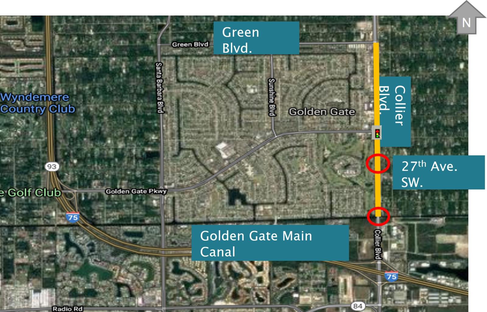 The project is located along Collier Boulevard between City Gate Boulevard North and Green Boulevard. The project involves widening Collier Boulevard from four- to six-lanes within the project limits (approximately 2.1 miles). This is the final project, in a series of five projects, to improve 15 miles of Collier Boulevard, from US 41 to Immokalee Road, to a six-lane roadway. This project includes widening within the median and along the west side of Collier Boulevard and realigns portions of the adjacent CR 951 Canal. Multimodal improvements include the addition of bike lanes along Collier Boulevard, as well as two 10-foot-wide shared-use pathways along the west side of Collier Boulevard and along the west side of 39th Street SW.
The Collier Boulevard Widening Project will remove the existing bridge at 25th Avenue SW to accommodate the proposed improvements. The new replacement bridge will be at 27th Avenue SW.
At a Public Information Meeting in December 2024 the 90% design plans for typical sections as well as the roadway plans for Collier Blvd from Green Blvd to Golden Gate Parkway and between 25th Ave SW and City Gate Blvd N were presented.
(Project Manager: Katherine Chachere)
This project includes new sidewalk segments along the north side of Frank Whiteman Boulevard, Cooper Drive, Illinois Drive, and Wisconsin Drive from 10th Street N. to 14th Street N.
The project, in coordination with the Florida Department of Transportation (FDOT), is at the sixty-percent design plans stage for 5-foot-wide concrete sidewalks. Construction may begin in the fall of 2026.
A public information meeting took place on Aug. 18, 2025 where a handout(PDF, 1MB) , as well as a typical section display(PDF, 1MB) and maps showing the proposed sidewalks(PDF, 2MB) were presented.
(Project Manager: Mark McCleary, P.E.)
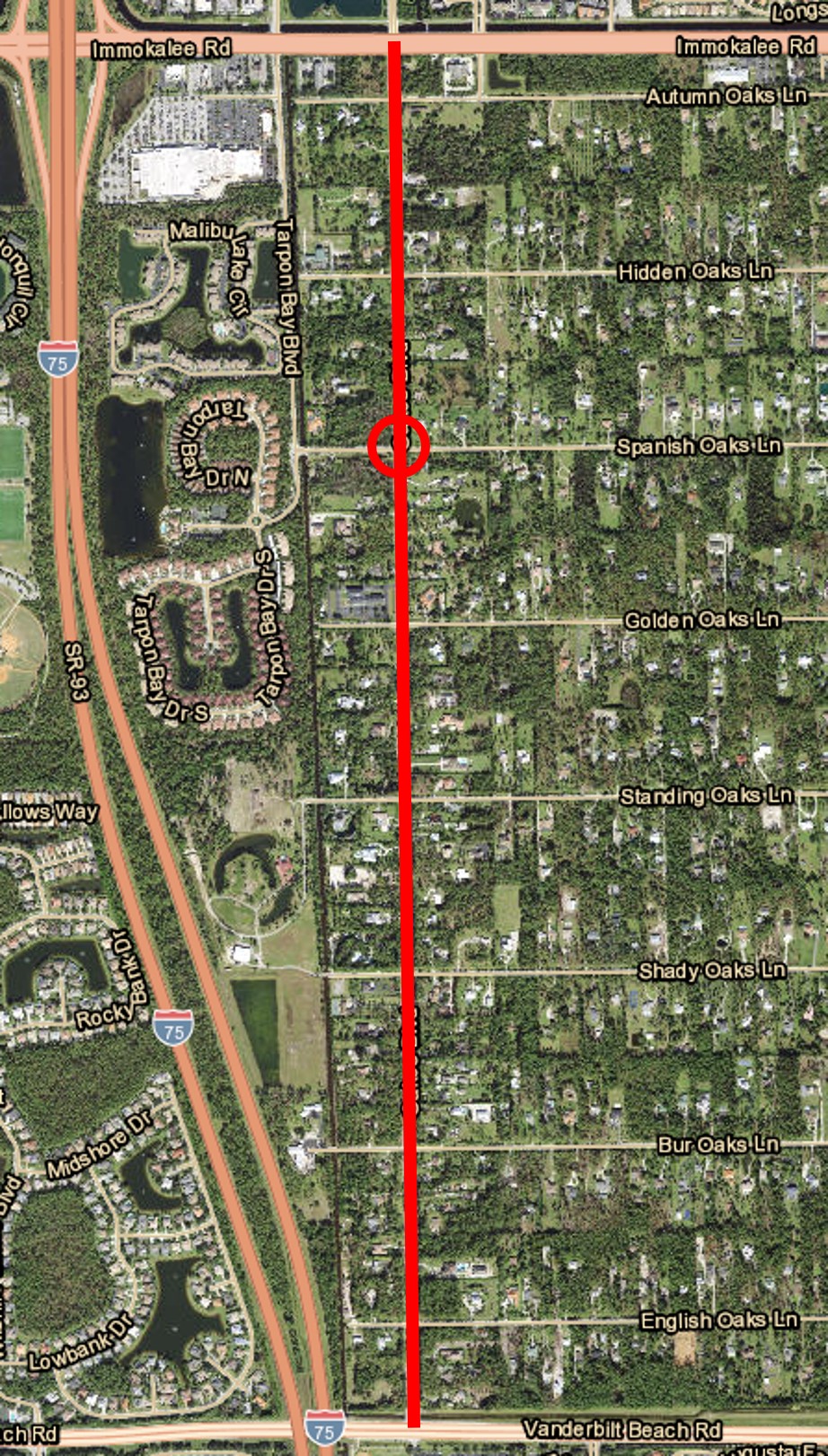 The project will add approximately two miles of sidewalk along the east side of Oakes Boulevard and reconstruct the existing eight-foot multiuse trail on the west side of the roadway. Additionally, a roundabout for the intersection of Oakes Boulevard and Spanish Oakes Lane is part of the plans.
A 75 percent design plans public information meeting was held on Wednesday, Aug. 28, 2024. A map showing the project improvements was on display at the meeting.
(Project Manager: Dennis McCoy, P.E.) 
A “jughandle” is proposed for the intersection of Pine Ridge Road and Livingston Road. This intersection design removes the left turn movements of Livingston Road and the eastbound right turn movement of Pine Ridge Road from the main intersection and diverts the traffic onto the jughandle. The removal of these turning movements from the main intersection increases overall intersection efficiency by providing more signal “green” time for Pine Ridge Road movements.
A 60 Percent Design Public Information Meeting was held on Thursday, June 18, 2026. The following information was presented at the meeting:
(Project Manager: Dennis McCoy, P.E.)
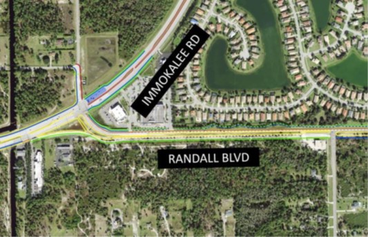 This project covers about a 3/4-mile stretch of Randall Blvd. (from Immokalee Road east to 8th Street NE) and a 1/2-mile stretch of Immokalee Road from east of Wilson Boulevard North to east of the Neighborhood Shoppes at Orangetree Shopping Center. The proposed improvement is to upgrade the current two-lane undivided road on Randall Blvd. to a four-lane divided road with a 44-foot median and provide three left turn lanes from westbound Randall Blvd. onto westbound Immokalee Road.
Signal upgrades will be included at the intersection of Immokalee Road and Randall Blvd. due to the new lane configurations. There will be a new 11-foot-wide continuous flow right turn lane from eastbound Immokalee Road to eastbound Randall Blvd.
A 30 Percent Design Plans Public Information Meeting was held on Wednesday, Nov. 6, 2024. At the meeting, a handout was available as well as displays of the project layout.
(Project Manager: Felipe Baez)

This bridge is located on SR 92, also known as San Marco Road. The project’s repairs consist of structural repairs to the bridge deck, columns, foundation, and other areas. There will also be environmental improvements in several locations to address and mitigate scour issues. M&J Construction was awarded a $8.94M contract to complete this project. Drivers are advised that intermittent lane closures will be needed. A temporary signal will be deployed to move traffic safely across the bridge. Boaters are reminded to use caution in the bridge area and watch for construction equipment and personnel. This project is expected to be completed by spring of 2027. Further details are included in the news release from March 9, 2026.(PDF, 207KB)

(Project Manager: Julio Castro)
COMPLETED
The Vanderbilt Beach Road Extension (Collier Boulevard to 16th Street NE) is an approximate 7-mile extension of the existing roadway. The project was completed and opened to the public on June 12, 2026.
(Project Manager: Robert White, P.E.)
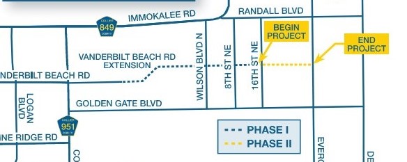 This approximate two-mile new roadway extension will continue Vanderbilt Beach Road to Everglades Blvd. (Extension Project Phase I is currently being constructed up to 16th St. NE). Phase II will be initially constructed as an undivided two-lane roadway with shoulders, curb and gutters, and a paved multi-use pathway The interim improvement is being designed within a four-lane divided roadway right-of-way footprint(PDF, 6MB) which will accommodate future projected traffic volumes.
A 60 Percent Design Plans Public Information Meeting was held on Wednesday, Oct. 2, 2024. A handout was prepared (which is also available in Spanish) and the project layout was displayed at the meeting.
(Project Manager: Dennis McCoy, P.E.)
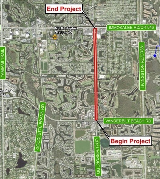
 This road widening project will expand Vanderbilt Beach Road from four to six lanes and extend approximately 1.8 miles from just east of US 41 to approximately the intersection of Vanderbilt Beach Road and Fontana Del Sol Way.
Much of the lane expansion will occur in the existing median. The project will include: improved roadway intersections at Strada Place and Goodlette-Frank Road; maintaining existing sidewalks and providing bike lanes; improved drainage throughout the project area.
Collier County held a public information meeting for the 60% Design Plans on Tuesday, March 30, 2021. A public information meeting newsletter, which includes a location map for the meeting, project limits and other important information was provided.
The meeting displays are available here:
The final design plans are currently under review and construction is slated to begin in summer of 2026.