Disclaimer Pop-up
We provide view support for all device resolutions.
For the best user experience, our maps are best viewed on a Desktop Computer.
Upon accessing any of our webmaps, you will be prompted to read and accept the terms and conditions.
Note: You can access this map guide within the Disclaimer pop-up window.

Navigating the Header
The header is located on the top portion of every webmap.
The top left corner will display the name of the webmap you are currently viewing.
In the top right corner, you will notice a few links that redirect to our services.
GIS Maps: Redirects to our library of Maps.
Apply for a Permit: Redirects you to our GMCD Portal Page.
Map Guide: Redirects you to this Map Guide.
Navigating the Map
There are several tools available on the map. Below is a list of each and its functions.
+ Symbol: Zooms in
- Symbol: Zooms Out
Home Icon: Zooms out to the County Boundary.
Back Arrow: Returns to your previous view.
Forward Arrow: Returns to your previous view.
Basemap Icon: Toggle between default map layers.
Map Layer Icon: You can toggle on and off specific map layers.
(Please note that certain features are only available when viewed at a specific zoom level)
*NOTE: These filters will change depending on the map you are viewing.
Legend Icon: Displays the City Limits.
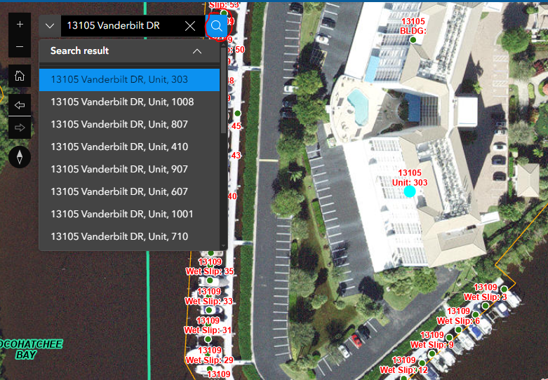
Search Function
The dropdown icon next to the search bar allows you to query your searches between Site Address Points, Parcels or PUDs.
*NOTE: These search filters will change depending on the map you are viewing.
Type in your address. In this example, we typed in 13105 Vanderbilt Dr and hit Enter on your keyboard (or you can select the Magnify Glass Icon next to the search bar)
Since our address has multiple units (stacked on a single building point) the Search Results will show the units located inside that point.
If there are too many results, you can also use your browser's search function to go to that result.
In some cases, you will notice that a parcel with fewer than 11 numbers will not show up on the search bar if the first number(s) start with a 0 (Zero).
In the example below, you will see that once we enter the 11-digit folio number and add the 0s to the parcel, the search bar will pick it up.
Selecting a Point
When selecting a point on the map, a pop-up will appear. Using the example address above, you will notice a few Icons.
Back Arrow: Toggles backwards between Parcel, PUD, Addressing Points, Etc.
Forward Arrow: Toggles forward between Parcel, PUD, Addressing Points, Etc.
List View Icon: View a list of all features within that point (Parcels, Addresses, Etc.).
Page Footer
At the bottom right corner of the map, you will see the County Logo, which will redirect you to the Collier County Website.